

Road safety plans/
Defining strategic lines in order to reduce accidents./
Road safety plans/
Defining strategic lines in order to reduce accidents./
Road safety aims to minimise accident figures. It can never be acceptable that citizens are killed or seriously injured by actively or passively using mobility networks and public space.
A road safety plan is a key document that reviews and suggests strategic lines as well as a series of coordinated actions to achieve the following objectives:
•To reduce mortality figures on streets and roads
•To ensure that an increase in mobility is compatible with road safety improvements
•To improve safety conditions, especially in places with most deficiencies
•To ensure a respect for signage and encourage information exchange with other agencies
•To promote the dissemination of information on accidents to raise awareness in society
Local road safety plans in urban environments are essential tools that can help to identify and correct the points/sections of roads where urban accidents are concentrated, paying special attention to those involving the most vulnerable users, such as pedestrians and cyclists.
Cinesi has road safety conscious professionals contributing their experience in assessing and dealing with accident figures, both in urban and interurban environments, by analysing risks and critical points of mobility in order to provide comprehensive solutions throughout a territory.
Road safety aims to minimise accident figures. It can never be acceptable that citizens are killed or seriously injured by actively or passively using mobility networks and public space.
A road safety plan is a key document that reviews and suggests strategic lines as well as a series of coordinated actions to achieve the following objectives:
•To reduce mortality figures on streets and roads
•To ensure that an increase in mobility is compatible with road safety improvements
•To improve safety conditions, especially in places with most deficiencies
•To ensure a respect for signage and encourage information exchange with other agencies
•To promote the dissemination of information on accidents to raise awareness in society
Local road safety plans in urban environments are essential tools that can help to identify and correct the points/sections of roads where urban accidents are concentrated, paying special attention to those involving the most vulnerable users, such as pedestrians and cyclists.
Cinesi has road safety conscious professionals contributing their experience in assessing and dealing with accident figures, both in urban and interurban environments, by analysing risks and critical points of mobility in order to provide comprehensive solutions throughout a territory.
Tools/
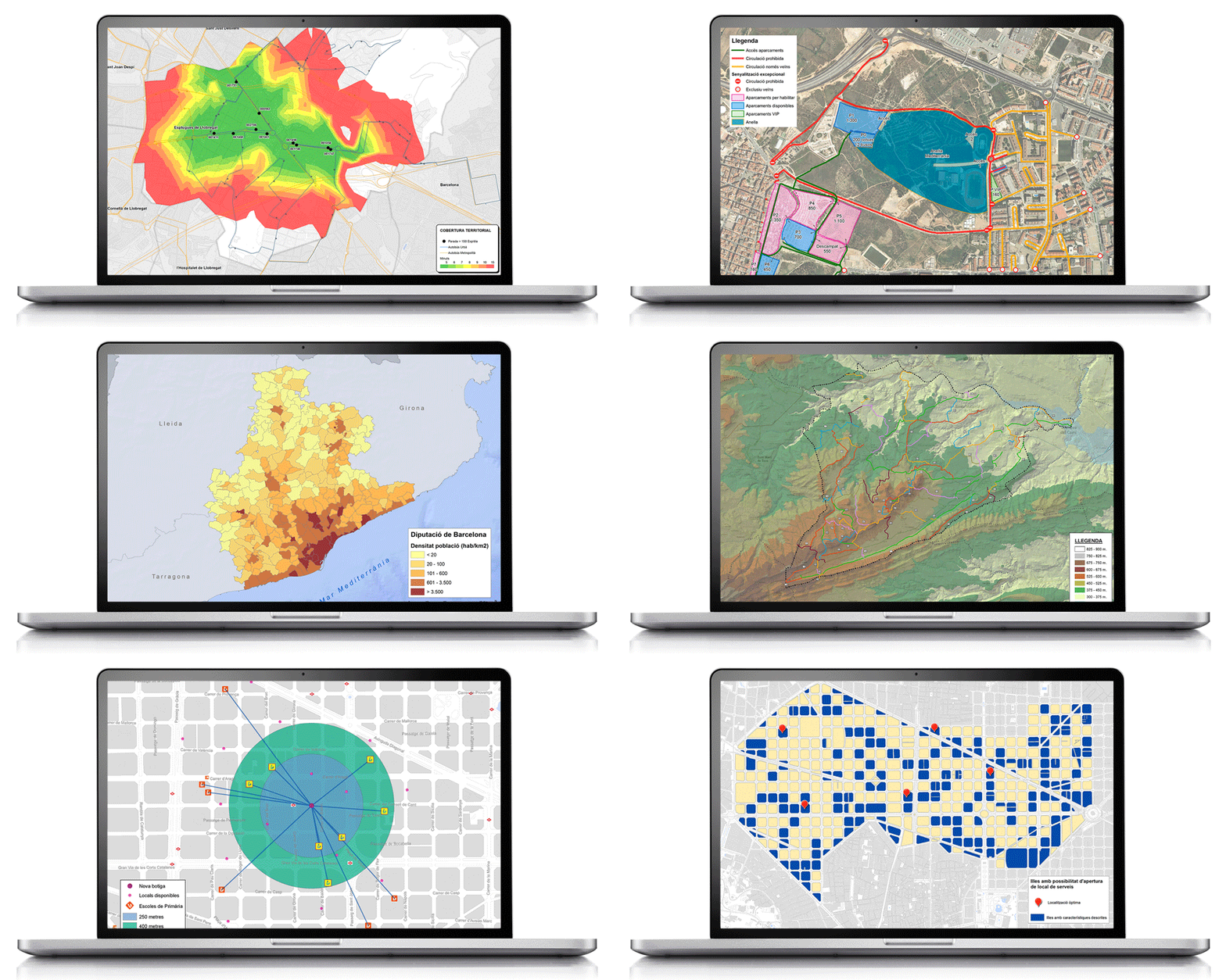
A geographic information system (GIS) is a sophisticated analytical tool we commonly use that is part of a number of new information technologies. It is a system that can store, analyse and display geographical information. It therefore has the peculiarity of integrating the variable of space, which makes it a very powerful tool to support any type of study or project in order to help in the decision-making process.
In the above charts you can see some of its applications in Cinesi’s projets.
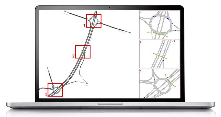
Simulation models are very useful computer programs that help to plan and manage transport. Their applications include network analysis, passenger transport analysis, the creation of demand and transport planning models, the design of vehicle routes and logistics and also territorial management, among others.
Here at Cinesi we use two simulation models according to the field of study: TransCAD for macroscopic fields and AIMSUN for smaller fields.
TransCAD: This is a macroscopic simulation model that is primarily used to study mobility on supramunicipal roads. The program uses a geographic information system (GIS) to help store and analyse data for any type of transport.
AIMSUN: This is a microscopic simulation model used to study mobility in urban networks. It allows vehicle-to-vehicle tracking and visualisation of this in real time. The impact of future actions on road networks can be observed based on the simulation of various modes of transport and the visualisation of how various stakeholders circulate, thereby helping to identify potential conflict points.
AUTOTURN: Simulation model of turning vehicles and analysis of sweeping areas based on the current or future road geometry for light and heavy vehicles and buses.
Cinesi performs a variety of fieldwork tasks to obtain both mobility data and information on the state of networks. Here are just a few:
1. Capacity/
Automated. Automated capacity machines to record traffic intensity and vehicle speed. They help calculate hourly and daily changes by type of vehicle and circulation direction.
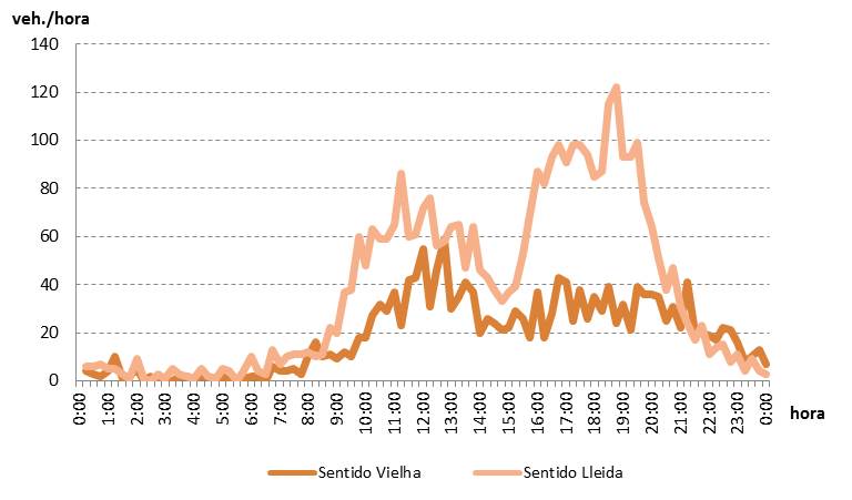
Directional. Helping to identify the route of pedestrians, bicycles, private vehicles, heavy vehicles, etc.

License plate reading. In order to obtain the route of motor vehicles by controlling access and intermediate checkpoints.
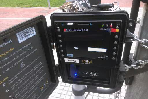
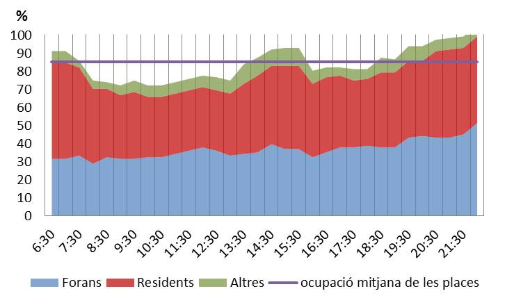
Parking. Analysis of occupancy (times that each space is occupied) and rotation (number of parked vehicles), identification of residence of vehicles parked and parking illegalities.
2. Inventories/
Analysis of the physical aspects of networks and photographic and/or video gathering that helps to define the condition of each section in a highly visual manner. Cinesi has the following specific material resources for conducting inventories:
4-wheel-drive vehicle. This vehicle incorporates a odometer and inclinometer to measure the length and tilt of the route, as well as a GPS receiver.
—

ArcGIS Field Maps. A mobile application that streamlines the process of accurate data gathering to be processed in the office during fieldwork.


Cinesi also specialises in monitoring and analysing surveys to identify mobility habits. These are a vital source for supporting the diagnoses and action plans we propose and can be outsourced to market research companies, with Cinesi overseeing these, or directly undertaken by Cinesi with contracted staff for the occasion. We handle the following tasks:
- Designing the survey by taking into account the objectives to be extracted
- Selecting the sample either randomly or from a particular group
- Conducting the survey, if required
- Data entry, if required
- Exploiting the obtained databases

The mysterious shopper technique helps to obtain detailed information on the conditions of providing a transport service. It is a vital tool for measuring, analysing and improving aspects related to customer service.
Acting anonymously as regular customers, specialised evaluators assess key aspects related to the perception of service users, such as information on board and at stops, quality of driving, stare of cleanliness and maintenance inside and outside the vehicles and also at stops, etc.
The resulting report presented by Cinesi includes all the information gathered, including quantitative and qualitative assessments and corresponding recommendations for improvement.

The pollutants emitted into the air by transport have a negative impact on the environment, so it is extremely important to identify and quantify their magnitude in order to implement measures.
Cinesi calculates emissions and environmental indicators based on (urban and interurban) transport networks and the environmental targets in question, thereby helping to compare modal quotas and existing emissions with those forecast in future scenarios.
One of the tools we use is AMBIMOB 2.0, from the Ministry of the Environment and Sustainability, which helps to environmentally assess the measures of sustainable urban mobility plans (SUMPs), thereby helping to observe the contribution of the measures with the planned reductions in mobility master plans, as well as the variation in emissions according to each pollutant.
—
—
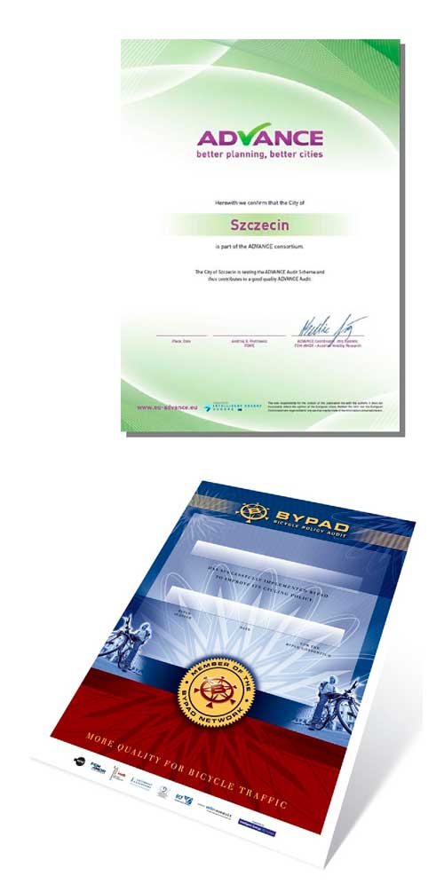
ADVANCE Audit is a certification tool for improving sustainable urban mobility plans, analysing the strengths and weaknesses of a city’s current mobility planning and providing directions on how to improve this in terms of sustainability.
—
—
There are a great many benefits for cities participating in the process of ADVANCE certification:
—
- Receiving an ADVANCE Action Plan containing action recommendations
- Benchmarking with other municipalities at a European level
- Improving the image of a city by showing that it is innovative and sustainable
- European recognised ADVANCE certification
—
—
BYPAD, an acronym for Bicycle Policy Audit, is a tool developed by an international consortium of bicycle experts as part of an EU-funded project. BYPAD provides an overview of the measures and structures applied in local cycling policy.
—
Cinesi uses it to be able to assess the quality of cycling policies of cities by analysing their strengths and weaknesses and making specific recommendations on how to improve their cycling policy in the future.

Geomarketing can be defined as the technique of analysing how geographical variables affect a business or activity. Geolocation and geospatial analysis help us to obtain an overview of the customers or users of a particular amenity, business, means of transport, etc.
It is a vital tool for answering such important questions as: Where are my customers and how do they behave? Where is the competition? Where can I open a new business? Or how accessible is my location and what geographical coverage do I have?
Cinesi is well versed in the tools of geomarketing and knows how useful it is for companies to obtain an accurate picture of the behaviour and mobility of their customers.
—
Analysis of major variables:
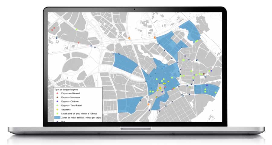
The analysis of major variables (demand, competition, area of influence or accessibility, among others) helps to obtain precise knowledge of the current situation and be able to make the right decisions regarding the optimal location to open an establishment, to identify the potential customer engagement area or the location of competitors.
—
Analysis of specific needs:
Based on studying the major variables of a business, geomarketing is also very useful for analysing specific, very concrete needs, such as:
- Distribution routes and points of sale
- Areas of influence of transport networks
- Reorganisation of points of sale or branches
- Studying cannibalisation areas
- Identifying areas not covered by a market network
- Mailshots and mailing
—
Tools/
A geographic information system (GIS) is a sophisticated analytical tool we commonly use that is part of a number of new information technologies. It is a system that can store, analyse and display geographical information. It therefore has the peculiarity of integrating the variable of space, which makes it a very powerful tool to support any type of study or project in order to help in the decision-making process.
In the above charts you can see some of its applications in Cinesi’s projets.
Simulation models are very useful computer programs that help to plan and manage transport. Their applications include network analysis, passenger transport analysis, the creation of demand and transport planning models, the design of vehicle routes and logistics and also territorial management, among others.
Here at Cinesi we use two simulation models according to the field of study: TransCAD for macroscopic fields and AIMSUN for smaller fields.
TransCAD: This is a macroscopic simulation model that is primarily used to study mobility on supramunicipal roads. The program uses a geographic information system (GIS) to help store and analyse data for any type of transport.
AIMSUN: This is a microscopic simulation model used to study mobility in urban networks. It allows vehicle-to-vehicle tracking and visualisation of this in real time. The impact of future actions on road networks can be observed based on the simulation of various modes of transport and the visualisation of how various stakeholders circulate, thereby helping to identify potential conflict points.
Cinesi performs a variety of fieldwork tasks to obtain both mobility data and information on the state of networks. Here are just a few:
1. Capacity/
Automated. Automated capacity machines to record traffic intensity and vehicle speed. They help calculate hourly and daily changes by type of vehicle and circulation direction.
Directional. Helping to identify the route of pedestrians, bicycles, private vehicles, heavy vehicles, etc.
License plate reading. In order to obtain the route of motor vehicles by controlling access and intermediate checkpoints.
Parking. Analysis of occupancy (times that each space is occupied) and rotation (number of parked vehicles), identification of residence of vehicles parked and parking illegalities.
2. Inventaries/
Analysis of the physical aspects of networks and photographic and/or video gathering that helps to define the condition of each section in a highly visual manner. Cinesi has the following specific material resources for conducting inventories:
4-wheel-drive vehicle. This vehicle incorporates a odometer and inclinometer to measure the length and tilt of the route, as well as a GPS receiver.
—
Collector for ArcGIS. A mobile application that streamlines the process of accurate data gathering to be processed in the office during fieldwork.
Cinesi also specialises in monitoring and analysing surveys to identify mobility habits. These are a vital source for supporting the diagnoses and action plans we propose and can be outsourced to market research companies, with Cinesi overseeing these, or directly undertaken by Cinesi with contracted staff for the occasion. We handle the following tasks:
- Designing the survey by taking into account the objectives to be extracted
- Selecting the sample either randomly or from a particular group
- Conducting the survey, if required
- Data entry, if required
- Exploiting the obtained databases
The mysterious shopper technique helps to obtain detailed information on the conditions of providing a transport service. It is a vital tool for measuring, analysing and improving aspects related to customer service.
Acting anonymously as regular customers, specialised evaluators assess key aspects related to the perception of service users, such as information on board and at stops, quality of driving, stare of cleanliness and maintenance inside and outside the vehicles and also at stops, etc.
The resulting report presented by Cinesi includes all the information gathered, including quantitative and qualitative assessments and corresponding recommendations for improvement.
The pollutants emitted into the air by transport have a negative impact on the environment, so it is extremely important to identify and quantify their magnitude in order to implement measures.
Cinesi calculates emissions and environmental indicators based on (urban and interurban) transport networks and the environmental targets in question, thereby helping to compare modal quotas and existing emissions with those forecast in future scenarios.
One of the tools we use is AMBIMOB 2.0, from the Ministry of the Environment and Sustainability, which helps to environmentally assess the measures of sustainable urban mobility plans (SUMPs), thereby helping to observe the contribution of the measures with the planned reductions in mobility master plans, as well as the variation in emissions according to each pollutant.
ADVANCE Audit is a certification tool for improving sustainable urban mobility plans, analysing the strengths and weaknesses of a city’s current mobility planning and providing directions on how to improve this in terms of sustainability.
—
There are a great many benefits for cities participating in the process of ADVANCE certification:
—
- Receiving an ADVANCE Action Plan containing action recommendations
- Benchmarking with other municipalities at a European level
- Improving the image of a city by showing that it is innovative and sustainable
- European recognised ADVANCE certification
BYPAD, an acronym for Bicycle Policy Audit, is a tool developed by an international consortium of bicycle experts as part of an EU-funded project. BYPAD provides an overview of the measures and structures applied in local cycling policy.
—
Cinesi uses it to be able to assess the quality of cycling policies of cities by analysing their strengths and weaknesses and making specific recommendations on how to improve their cycling policy in the future.
Geomarketing can be defined as the technique of analysing how geographical variables affect a business or activity. Geolocation and geospatial analysis help us to obtain an overview of the customers or users of a particular amenity, business, means of transport, etc.
It is a vital tool for answering such important questions as: Where are my customers and how do they behave? Where is the competition? Where can I open a new business? Or how accessible is my location and what geographical coverage do I have?
Cinesi is well versed in the tools of geomarketing and knows how useful it is for companies to obtain an accurate picture of the behaviour and mobility of their customers.
—
Analysis of major variables:
The analysis of major variables (demand, competition, area of influence or accessibility, among others) helps to obtain precise knowledge of the current situation and be able to make the right decisions regarding the optimal location to open an establishment, to identify the potential customer engagement area or the location of competitors.
—
Analysis of specific needs:
Based on studying the major variables of a business, geomarketing is also very useful for analysing specific, very concrete needs, such as:
- Distribution routes and points of sale
- Areas of influence of transport networks
- Reorganisation of points of sale or branches
- Studying cannibalisation areas
- Identifying areas not covered by a market network
- Mailshots and mailing
—
They trust us/








Shall we talk?/
Shall we talk?/

Tools/
A geographic information system (GIS) is a sophisticated analytical tool we commonly use that is part of a number of new information technologies. It is a system that can store, analyse and display geographical information. It therefore has the peculiarity of integrating the variable of space, which makes it a very powerful tool to support any type of study or project in order to help in the decision-making process.
In the above charts you can see some of its applications in Cinesi’s projets.
Simulation models are very useful computer programs that help to plan and manage transport. Their applications include network analysis, passenger transport analysis, the creation of demand and transport planning models, the design of vehicle routes and logistics and also territorial management, among others.
Here at Cinesi we use two simulation models according to the field of study: TransCAD for macroscopic fields and AIMSUN for smaller fields.
TransCAD: This is a macroscopic simulation model that is primarily used to study mobility on supramunicipal roads. The program uses a geographic information system (GIS) to help store and analyse data for any type of transport.
AIMSUN: This is a microscopic simulation model used to study mobility in urban networks. It allows vehicle-to-vehicle tracking and visualisation of this in real time. The impact of future actions on road networks can be observed based on the simulation of various modes of transport and the visualisation of how various stakeholders circulate, thereby helping to identify potential conflict points.
AUTOTURN: Simulation model of turning vehicles and analysis of sweeping areas based on the current or future road geometry for light and heavy vehicles and buses.
Cinesi performs a variety of fieldwork tasks to obtain both mobility data and information on the state of networks. Here are just a few:
1. Capacity/
Automated. Automated capacity machines to record traffic intensity and vehicle speed. They help calculate hourly and daily changes by type of vehicle and circulation direction.
Directional. Helping to identify the route of pedestrians, bicycles, private vehicles, heavy vehicles, etc.
License plate reading. In order to obtain the route of motor vehicles by controlling access and intermediate checkpoints.
Parking. Analysis of occupancy (times that each space is occupied) and rotation (number of parked vehicles), identification of residence of vehicles parked and parking illegalities.
2. Inventories/
Analysis of the physical aspects of networks and photographic and/or video gathering that helps to define the condition of each section in a highly visual manner. Cinesi has the following specific material resources for conducting inventories:
4-wheel-drive vehicle. This vehicle incorporates a odometer and inclinometer to measure the length and tilt of the route, as well as a GPS receiver.
—
ArcGIS Field Maps. A mobile application that streamlines the process of accurate data gathering to be processed in the office during fieldwork.
Cinesi also specialises in monitoring and analysing surveys to identify mobility habits. These are a vital source for supporting the diagnoses and action plans we propose and can be outsourced to market research companies, with Cinesi overseeing these, or directly undertaken by Cinesi with contracted staff for the occasion. We handle the following tasks:
- Designing the survey by taking into account the objectives to be extracted
- Selecting the sample either randomly or from a particular group
- Conducting the survey, if required
- Data entry, if required
- Exploiting the obtained databases
The mysterious shopper technique helps to obtain detailed information on the conditions of providing a transport service. It is a vital tool for measuring, analysing and improving aspects related to customer service.
Acting anonymously as regular customers, specialised evaluators assess key aspects related to the perception of service users, such as information on board and at stops, quality of driving, stare of cleanliness and maintenance inside and outside the vehicles and also at stops, etc.
The resulting report presented by Cinesi includes all the information gathered, including quantitative and qualitative assessments and corresponding recommendations for improvement.
The pollutants emitted into the air by transport have a negative impact on the environment, so it is extremely important to identify and quantify their magnitude in order to implement measures.
Cinesi calculates emissions and environmental indicators based on (urban and interurban) transport networks and the environmental targets in question, thereby helping to compare modal quotas and existing emissions with those forecast in future scenarios.
One of the tools we use is AMBIMOB 2.0, from the Ministry of the Environment and Sustainability, which helps to environmentally assess the measures of sustainable urban mobility plans (SUMPs), thereby helping to observe the contribution of the measures with the planned reductions in mobility master plans, as well as the variation in emissions according to each pollutant.
—
—
ADVANCE Audit is a certification tool for improving sustainable urban mobility plans, analysing the strengths and weaknesses of a city’s current mobility planning and providing directions on how to improve this in terms of sustainability.
—
—
There are a great many benefits for cities participating in the process of ADVANCE certification:
—
- Receiving an ADVANCE Action Plan containing action recommendations
- Benchmarking with other municipalities at a European level
- Improving the image of a city by showing that it is innovative and sustainable
- European recognised ADVANCE certification
—
—
BYPAD, an acronym for Bicycle Policy Audit, is a tool developed by an international consortium of bicycle experts as part of an EU-funded project. BYPAD provides an overview of the measures and structures applied in local cycling policy.
—
Cinesi uses it to be able to assess the quality of cycling policies of cities by analysing their strengths and weaknesses and making specific recommendations on how to improve their cycling policy in the future.
Geomarketing can be defined as the technique of analysing how geographical variables affect a business or activity. Geolocation and geospatial analysis help us to obtain an overview of the customers or users of a particular amenity, business, means of transport, etc.
It is a vital tool for answering such important questions as: Where are my customers and how do they behave? Where is the competition? Where can I open a new business? Or how accessible is my location and what geographical coverage do I have?
Cinesi is well versed in the tools of geomarketing and knows how useful it is for companies to obtain an accurate picture of the behaviour and mobility of their customers.
—
Analysis of major variables:
The analysis of major variables (demand, competition, area of influence or accessibility, among others) helps to obtain precise knowledge of the current situation and be able to make the right decisions regarding the optimal location to open an establishment, to identify the potential customer engagement area or the location of competitors.
—
Analysis of specific needs:
Based on studying the major variables of a business, geomarketing is also very useful for analysing specific, very concrete needs, such as:
- Distribution routes and points of sale
- Areas of influence of transport networks
- Reorganisation of points of sale or branches
- Studying cannibalisation areas
- Identifying areas not covered by a market network
- Mailshots and mailing
—
Tools/
A geographic information system (GIS) is a sophisticated analytical tool we commonly use that is part of a number of new information technologies. It is a system that can store, analyse and display geographical information. It therefore has the peculiarity of integrating the variable of space, which makes it a very powerful tool to support any type of study or project in order to help in the decision-making process.
In the above charts you can see some of its applications in Cinesi’s projets.
Simulation models are very useful computer programs that help to plan and manage transport. Their applications include network analysis, passenger transport analysis, the creation of demand and transport planning models, the design of vehicle routes and logistics and also territorial management, among others.
Here at Cinesi we use two simulation models according to the field of study: TransCAD for macroscopic fields and AIMSUN for smaller fields.
TransCAD: This is a macroscopic simulation model that is primarily used to study mobility on supramunicipal roads. The program uses a geographic information system (GIS) to help store and analyse data for any type of transport.
AIMSUN: This is a microscopic simulation model used to study mobility in urban networks. It allows vehicle-to-vehicle tracking and visualisation of this in real time. The impact of future actions on road networks can be observed based on the simulation of various modes of transport and the visualisation of how various stakeholders circulate, thereby helping to identify potential conflict points.
Cinesi performs a variety of fieldwork tasks to obtain both mobility data and information on the state of networks. Here are just a few:
1. Capacity/
Automated. Automated capacity machines to record traffic intensity and vehicle speed. They help calculate hourly and daily changes by type of vehicle and circulation direction.
Directional. Helping to identify the route of pedestrians, bicycles, private vehicles, heavy vehicles, etc.
License plate reading. In order to obtain the route of motor vehicles by controlling access and intermediate checkpoints.
Parking. Analysis of occupancy (times that each space is occupied) and rotation (number of parked vehicles), identification of residence of vehicles parked and parking illegalities.
2. Inventaries/
Analysis of the physical aspects of networks and photographic and/or video gathering that helps to define the condition of each section in a highly visual manner. Cinesi has the following specific material resources for conducting inventories:
4-wheel-drive vehicle. This vehicle incorporates a odometer and inclinometer to measure the length and tilt of the route, as well as a GPS receiver.
—
Collector for ArcGIS. A mobile application that streamlines the process of accurate data gathering to be processed in the office during fieldwork.
Cinesi also specialises in monitoring and analysing surveys to identify mobility habits. These are a vital source for supporting the diagnoses and action plans we propose and can be outsourced to market research companies, with Cinesi overseeing these, or directly undertaken by Cinesi with contracted staff for the occasion. We handle the following tasks:
- Designing the survey by taking into account the objectives to be extracted
- Selecting the sample either randomly or from a particular group
- Conducting the survey, if required
- Data entry, if required
- Exploiting the obtained databases
The mysterious shopper technique helps to obtain detailed information on the conditions of providing a transport service. It is a vital tool for measuring, analysing and improving aspects related to customer service.
Acting anonymously as regular customers, specialised evaluators assess key aspects related to the perception of service users, such as information on board and at stops, quality of driving, stare of cleanliness and maintenance inside and outside the vehicles and also at stops, etc.
The resulting report presented by Cinesi includes all the information gathered, including quantitative and qualitative assessments and corresponding recommendations for improvement.
The pollutants emitted into the air by transport have a negative impact on the environment, so it is extremely important to identify and quantify their magnitude in order to implement measures.
Cinesi calculates emissions and environmental indicators based on (urban and interurban) transport networks and the environmental targets in question, thereby helping to compare modal quotas and existing emissions with those forecast in future scenarios.
One of the tools we use is AMBIMOB 2.0, from the Ministry of the Environment and Sustainability, which helps to environmentally assess the measures of sustainable urban mobility plans (SUMPs), thereby helping to observe the contribution of the measures with the planned reductions in mobility master plans, as well as the variation in emissions according to each pollutant.
ADVANCE Audit is a certification tool for improving sustainable urban mobility plans, analysing the strengths and weaknesses of a city’s current mobility planning and providing directions on how to improve this in terms of sustainability.
—
There are a great many benefits for cities participating in the process of ADVANCE certification:
—
- Receiving an ADVANCE Action Plan containing action recommendations
- Benchmarking with other municipalities at a European level
- Improving the image of a city by showing that it is innovative and sustainable
- European recognised ADVANCE certification
BYPAD, an acronym for Bicycle Policy Audit, is a tool developed by an international consortium of bicycle experts as part of an EU-funded project. BYPAD provides an overview of the measures and structures applied in local cycling policy.
—
Cinesi uses it to be able to assess the quality of cycling policies of cities by analysing their strengths and weaknesses and making specific recommendations on how to improve their cycling policy in the future.
Geomarketing can be defined as the technique of analysing how geographical variables affect a business or activity. Geolocation and geospatial analysis help us to obtain an overview of the customers or users of a particular amenity, business, means of transport, etc.
It is a vital tool for answering such important questions as: Where are my customers and how do they behave? Where is the competition? Where can I open a new business? Or how accessible is my location and what geographical coverage do I have?
Cinesi is well versed in the tools of geomarketing and knows how useful it is for companies to obtain an accurate picture of the behaviour and mobility of their customers.
—
Analysis of major variables:
The analysis of major variables (demand, competition, area of influence or accessibility, among others) helps to obtain precise knowledge of the current situation and be able to make the right decisions regarding the optimal location to open an establishment, to identify the potential customer engagement area or the location of competitors.
—
Analysis of specific needs:
Based on studying the major variables of a business, geomarketing is also very useful for analysing specific, very concrete needs, such as:
- Distribution routes and points of sale
- Areas of influence of transport networks
- Reorganisation of points of sale or branches
- Studying cannibalisation areas
- Identifying areas not covered by a market network
- Mailshots and mailing
—
They trust us/
Shall we talk?/
Shall we talk?/